EDUCATION/EXPLORATION/RECREATION

  • Home
  • Membership
    • Online Registration
    • Online Dues Payment
    • Member Listing
    • Member Login
  • Club Meetings
    • Past Meeting Presentations
    • Club Calendar
    • WVAC’s YouTube Channel
  • Star Party
    • Party Schedule
    • Party Location
    • Recreation Permit
    • Party Etiquette
    • Notification Form
    • What to Bring
    • Weather
    • Objects in the sky
  • Outreach
    • Past Outreach Events
    • Library Telescope Program
    • Solar Telescope
  • Field Trips
    • Past Field Trips
    • Night Sky Network
  • Astroimaging
    • Astro Photographers
    • Astroimaging Forum
    • Astroimaging Meeting Presentations
    • Astroimaging Tools
    • Astroimaging Edc.
  • Resources
    • Light Pollution Map
    • Dark Sky Locations
    • Local Observatories
    • Astronomy Tools
    • Astronomy Edc.
    • General Resources
    • Forsale Astronomy/Telescopes
    • Comet C2023 A3
    • Astronomy 3D Printing

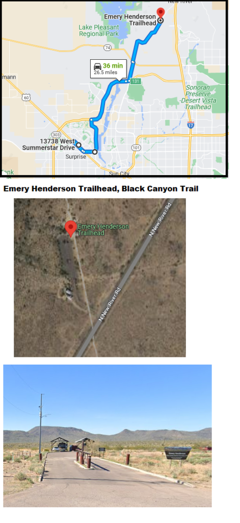
Emery Henderson Trailhead

This is a developed facility with paved parking, including several pull-through parking spaces for vehicles with trailers. There are covered picnic tables (ramadas), restrooms, information kiosk and railings to tether horses. From Interstate 17: Take exit 232, turn west on New River Road, drive approximately 3.3 miles, look for sign on the right, turn right into Emery Henderson driveway.

GPS coordinates, using NAD27 datum: N33º 52.772’ W112º 10.760’

If hosts are present, check in regarding staying in the parking lot after normal hours.
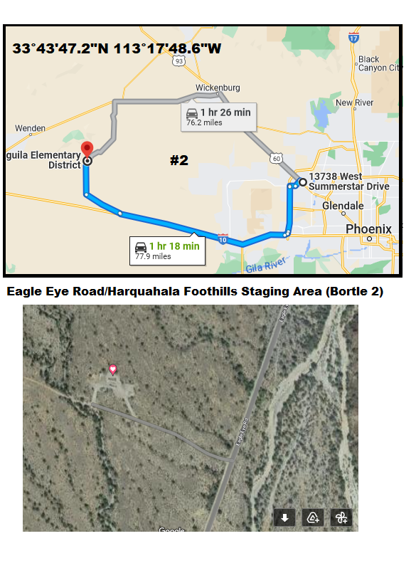
Eagle Eye Road Harquahala Foothills Staging Area

Chris Mahar

33°43’47.2″N 113°17’48.6″W
A farther drive, but way darker skies. This is a 61 minute drive from my house, most of it at freeway speed.
Take I-10 WEST until Exit 81 for Salome Road. Take Salome Road northwest for 9.6 miles (Open range, watch for cattle), turn right on Eagle Eye road, paved road. Go 8.4 miles north on Eagle Eye road. Turn left (West) onto a dirt road for the Harquahala Foothills Staging Area, about 0.2 miles off the pavement. Good wide area, almost never anyone there. Pit toilet. Picnic table. Set up on north part of clearing.
Not on state trust land. BLM land only.

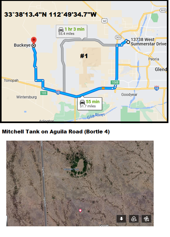
Mitchell Tank on Aquila Road

Chris Mahar
33°38’13.4″N 112°49’34.7″W
Take I-10 West. Exit at 339th Ave (Travel America) and go north.
Turn Left at Indian School. Turn Right (north) at Aguila Road (the solar plant).
Go past the 3.3 miles CAP canal. You’ll see a clump of trees on the right (east) side of the road. That’s Mitchell Tank. If it’s dark, look for drag racing marks on the pavement. Sometimes kids use the paved road for drag racing b/c it’s so straight and flat.
Turn right (east) off the pavement. It’s flat dirt and desert pavement (flat rocky surface).  Turn right (south) before the barbed wire fence surrounding Mitchell Tank. I usually go a couple hundred yards to the south. Nice and flat, could accommodate many cars.
Lights of Phoenix are somewhat blocked by the White Tank mountains, but still, the eastern third of the sky isn’t usable.
I wouldn’t use this site after a big rain. It would be muddy.  This land is an incorporated part of Buckeye. The water hole is controlled by Game & Fish.

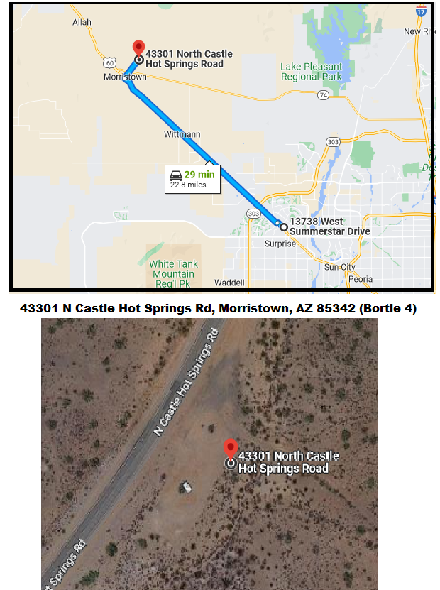
Castle Hot Springs Road, Morrestown AZ

WVAC Club Star Party Location

This is a staging area during the day for ATVers

(Arizona State Land Permit Required)

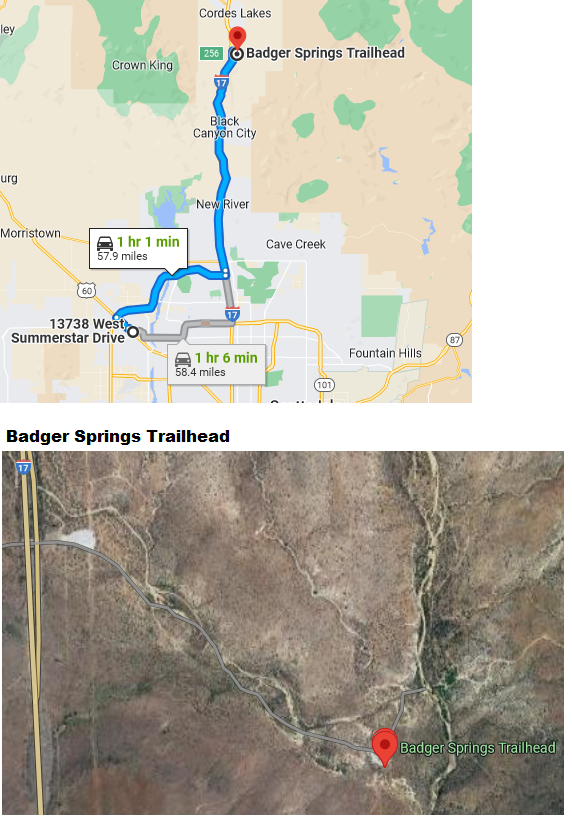
Badger Springs Trailhead

Luke Edens: Badger Springs trailhead is where I do my dark sky work and host events. The site allows for overnight camping and has a toilet pit nearby. I also sponsor the clear-sky online map for that location.

Thomas Mastrocinque: Just don’t go on three-day weekends if you want to be alone. It can get busy during some weekends. I take the dirt path all the way to the end. If you have a truck, you can go off-road even further.

Click here for a link to site writeup

  • « Previous Page
  • 1
  • 2
  • About
  • Contact Us
  • Members Only
  • Member Login

Copyright © 2026 · West Valley Astronomy Club